August: Dillon, MT to Lemhi Pass. It took me a day and a half to get
17-20 to Clark Canyon Dam. There were more sections than usual
which I could paddle, until I got to within 10 miles of the
dam. After that I was pulling the kayak all the way through
some fairly swift current. At one point, near Hightower
Rock, the current was so strong, the channel so deep, and
the water so cold that I had to take the kayak out , strap on
the wheels, and pull it up the road for a couple of miles. The
last mile was fairly level, so I was able to paddle up to the
dam.
At the dam I checked in with the Carrolls, who were working
on my portage over Lemhi Pass. No luck - they couldnt find
anybody. Not knowing what else to do, I turned my kayak
around and paddled back to Dillon, hoping that one of the
outfitters there could get my gear across the pass. It took
me less than 5 hours to get to Dillon going downstream, and
once there I was able to find a ride to Tendoy, Idaho for my
kayak. I got my gear across the pass, rode back to the
dam, and started my hike across the Continental Divide. By
late afternoon I reached a bed and breakfast in Grant, MT,
the Prairie Horse Hilton, and spent the night there, then
continued on to Lemhi Pass on Sunday.
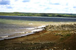 On shore after a long day.
The 35 miles from Clark Canyon to Lemhi Pass traverses a
high, arid plateau. Lewis and Clark followed Horse Prairie
Creek and Trail Creek through this area and up to the pass.
Most of Prairie Creek goes through private land, much of
which is fenced off, so I hiked along Rt. 324, a paved
highway which parallels Horse Prairie Creek until the Lemhi
Pass road picks up Trail Creek and heads west. The road to
the pass is not paved, and gradually ascends through dry
prairie before it winds more steeply through Ponderosa pine
forest to the Continental Divide.
I camped at the Sacajawea Memorial at the Divide (altitude
7373 feet) on Sunday night, right beside the spring that
Lewis considered the source of the Missouri. Like Lewis, I
dipped my cup into the spring, took a long drink, and
toasted the rivers to my east. I went to sleep with a mixture
of emotions: a tremendous sense of accomplishment at
having completed more than 2500 miles of upstream
paddling, combined with a certain wistfulness at leaving the
Missouri behind and an eager anticipation of heading
downstream for the first time in more than 4 months.
Click here for days 136 - 144 of Richard's journal
On shore after a long day.
The 35 miles from Clark Canyon to Lemhi Pass traverses a
high, arid plateau. Lewis and Clark followed Horse Prairie
Creek and Trail Creek through this area and up to the pass.
Most of Prairie Creek goes through private land, much of
which is fenced off, so I hiked along Rt. 324, a paved
highway which parallels Horse Prairie Creek until the Lemhi
Pass road picks up Trail Creek and heads west. The road to
the pass is not paved, and gradually ascends through dry
prairie before it winds more steeply through Ponderosa pine
forest to the Continental Divide.
I camped at the Sacajawea Memorial at the Divide (altitude
7373 feet) on Sunday night, right beside the spring that
Lewis considered the source of the Missouri. Like Lewis, I
dipped my cup into the spring, took a long drink, and
toasted the rivers to my east. I went to sleep with a mixture
of emotions: a tremendous sense of accomplishment at
having completed more than 2500 miles of upstream
paddling, combined with a certain wistfulness at leaving the
Missouri behind and an eager anticipation of heading
downstream for the first time in more than 4 months.
Click here for days 136 - 144 of Richard's journal